Overview
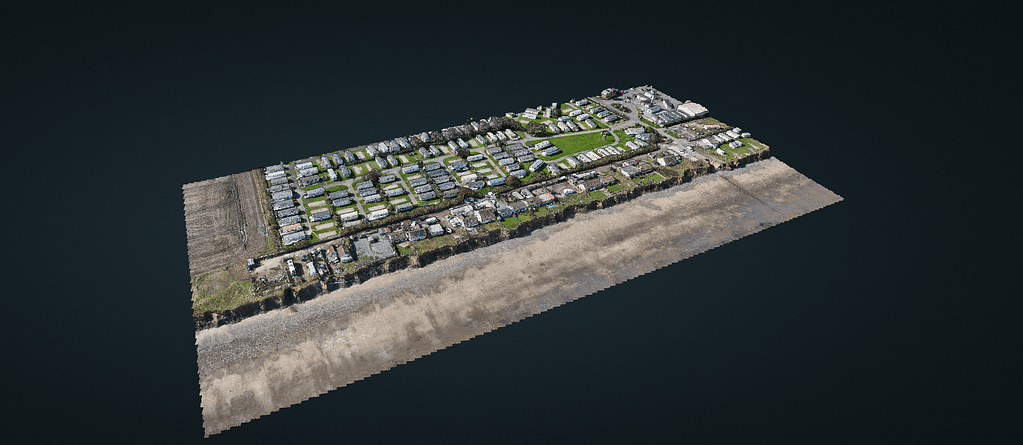
CreoPlan has revolutionised coastal monitoring along the East Yorkshire coast, establishing the region’s most comprehensive survey programme. Currently monitoring 60% of East Yorkshire’s coastline, our work spans from the chalk cliffs of Flamborough Head to the unique landscape of Spurn Point, encompassing fifteen critical coastal sections. This extensive coverage has positioned CreoPlan as the definitive authority on coastal change in the region.
The Challenge – Coastal Erosion for ERYC
East Yorkshire’s coastline represents one of Britain’s most dynamic coastal environments, experiencing unprecedented erosion rates that pose significant threats to infrastructure, communities, and heritage sites. Traditional surveying methods have proven inadequate for capturing the rapid changes occurring along this vulnerable coastline. The complex interaction of geological formations, varying erosion rates, and diverse coastal defence structures demands a more sophisticated approach to monitoring and analysis.
Technical Innovation – Coastal Surveying
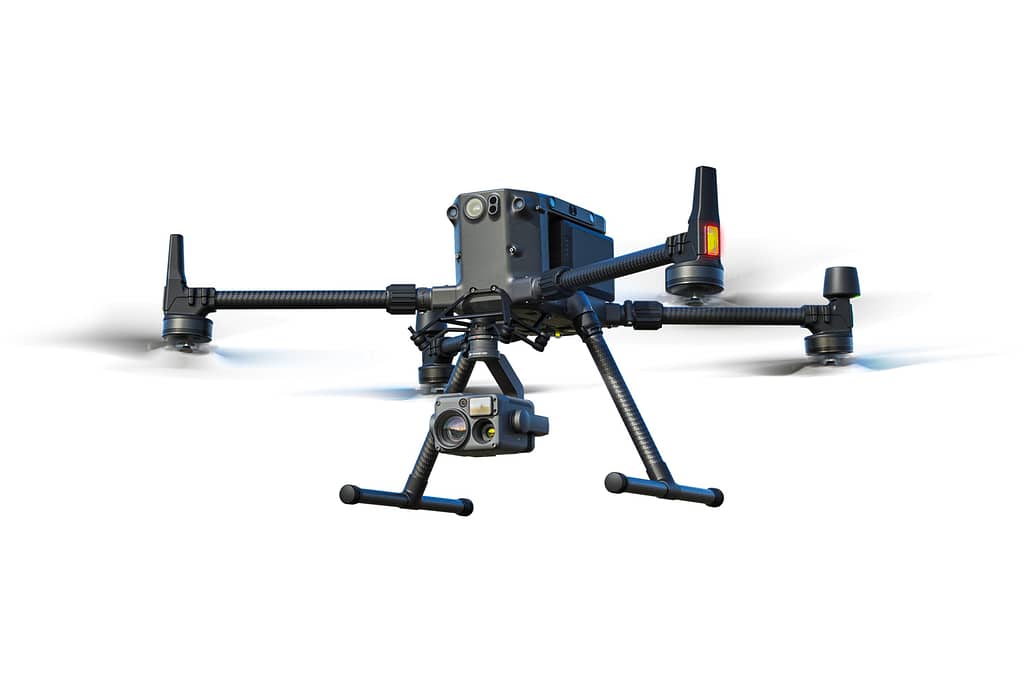
Our response to these challenges has been to develop and implement a state-of-the-art survey methodology that combines multiple data capture techniques. At the heart of our approach is the DJI M350 RTK platform, equipped with an integrated LiDAR system and complemented by high-resolution photogrammetry capabilities. This advanced system enables us to capture coastal change with unprecedented precision and reliability.
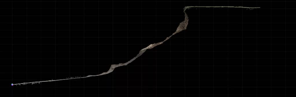
The foundation of our methodology rests on three distinct but complementary survey techniques. Our LiDAR scanning protocol involves multiple passes at carefully calculated angles, creating detailed point clouds that capture every nuance of the cliff face. This high-density data, collecting over 1000 points per square metre, provides the basis for precise change detection and analysis.
Methodology – CreoPlan’s Unique Coastal Surveying
Our comprehensive data capture protocol employs three distinct methodologies:
1. LiDAR Scanning
- Multiple passes at varying angles (15°, 45°, and 75°)
- Point cloud density >1000 points/m²
- Sub-millimetre accuracy in optimal conditions
- Real-time RTK positioning for absolute spatial reference
2. Photogrammetric Documentation
- Systematic flight paths with 75% overlap
- High-resolution imagery at multiple angles
- Automated and manual control point registration
- Integration with existing survey networks
3. Thermal Analysis
- Early morning/late evening capture for optimal thermal contrast
- Detection of:
- Subsurface water movement
- Structural weaknesses
- Potential failure points
- Ground water seepage
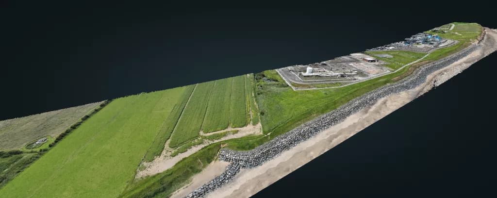
Real-World Application: Mappleton Case Study
Our work at Mappleton exemplifies the effectiveness of this comprehensive approach. Recent surveys of the cliff section revealed complex patterns of erosion that traditional monitoring methods had missed entirely. Through the integration of LiDAR, photogrammetry, and thermal imaging, we identified three previously undetected zones of weakness within the cliff structure.
The thermal imaging component proved particularly valuable, mapping subsurface water movement patterns that were contributing to accelerated erosion in specific areas. This information enabled local authorities to implement targeted intervention strategies before visible signs of failure appeared at the surface.
Impact and Future Directions
The success of our methodology along the East Yorkshire coast has established new standards in coastal monitoring. Our ability to deliver sub-millimetre accuracy in change detection, combined with comprehensive visual documentation and thermal analysis, provides stakeholders with unprecedented insight into coastal dynamics.
Looking forward, we are actively expanding our coverage along the East Yorkshire coast while continuously refining our methodology. Our work has evolved beyond pure monitoring to include predictive modelling of erosion patterns, assessment of coastal defence effectiveness, and long-term strategic planning for coastal communities.
Technical Benefits
This advanced methodology delivers:
- Unprecedented Accuracy
- Sub-millimetre measurement capability
- Highly repeatable results
- Precise change detection
- Comprehensive Data
- Multiple data types from single survey
- Rich contextual information
- Complete visual documentation
- Rapid Response
- Quick deployment capability
- Fast data processing
- Immediate preliminary results
Conclusion
Our advanced coastal monitoring programme represents a significant leap forward in understanding and managing coastal change along the East Yorkshire coast. By combining cutting-edge technology with systematic methodology and expert analysis, we provide stakeholders with the comprehensive insights needed to make informed decisions about coastal management and protection strategies.
The success of this programme demonstrates the value of investing in advanced monitoring technologies and methodologies. As coastal erosion continues to pose increasing challenges to communities and infrastructure, the importance of precise, reliable monitoring data becomes ever more critical. CreoPlan’s commitment to innovation and excellence ensures we remain at the forefront of this vital work.
Somebody essentially lend a hand to make significantly posts I might state That is the very first time I frequented your web page and up to now I surprised with the research you made to create this particular put up amazing Excellent job
Your blog is a constant source of inspiration for me. Your passion for your subject matter is palpable, and it’s clear that you pour your heart and soul into every post. Keep up the incredible work!
Your blog is a treasure trove of valuable insights and thought-provoking commentary. Your dedication to your craft is evident in every word you write. Keep up the fantastic work!
Your passion for your subject matter shines through in every post. It’s clear that you genuinely care about sharing knowledge and making a positive impact on your readers. Kudos to you!
Your blog is a constant source of inspiration for me. Your passion for your subject matter shines through in every post, and it’s clear that you genuinely care about making a positive impact on your readers.
Your writing is a true testament to your expertise and dedication to your craft. I’m continually impressed by the depth of your knowledge and the clarity of your explanations. Keep up the phenomenal work!
Your blog is a beacon of light in the often murky waters of online content. Your thoughtful analysis and insightful commentary never fail to leave a lasting impression. Keep up the amazing work!
Your blog is a constant source of inspiration for me. Your passion for your subject matter is palpable, and it’s clear that you pour your heart and soul into every post. Keep up the incredible work!
I just wanted to drop by and say how much I appreciate your blog. Your writing style is both engaging and informative, making it a pleasure to read. Looking forward to your future posts!
Thanks I have just been looking for information about this subject for a long time and yours is the best Ive discovered till now However what in regards to the bottom line Are you certain in regards to the supply
Your blog is a breath of fresh air in the crowded online space. I appreciate the unique perspective you bring to every topic you cover. Keep up the fantastic work!
I have been browsing online more than three hours today yet I never found any interesting article like yours It is pretty worth enough for me In my view if all website owners and bloggers made good content as you did the internet will be a lot more useful than ever before
Your blog is a breath of fresh air in the often mundane world of online content. Your unique perspective and engaging writing style never fail to leave a lasting impression. Thank you for sharing your insights with us.
Your blog is a testament to your dedication to your craft. Your commitment to excellence is evident in every aspect of your writing. Thank you for being such a positive influence in the online community.
Your blog is a true hidden gem on the internet. Your thoughtful analysis and engaging writing style set you apart from the crowd. Keep up the excellent work!
Your articles never fail to captivate me. Each one is a testament to your expertise and dedication to your craft. Thank you for sharing your wisdom with the world.
Wow amazing blog layout How long have you been blogging for you made blogging look easy The overall look of your web site is magnificent as well as the content
Your blog is a treasure trove of valuable insights and thought-provoking commentary. Your dedication to your craft is evident in every word you write. Keep up the fantastic work!